Software

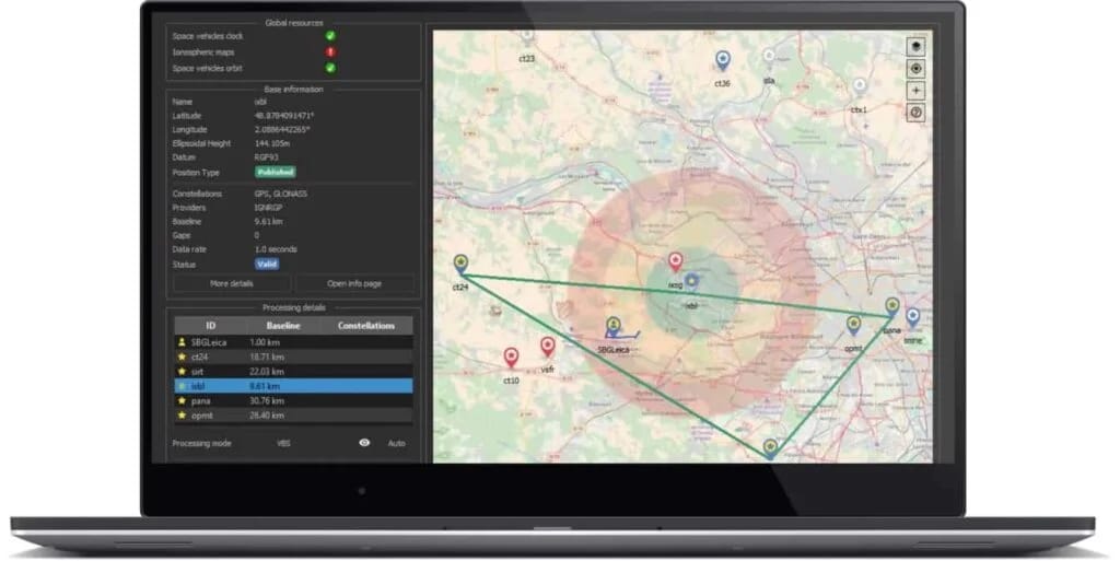
Qinertia Post-Processing Software SBG Systems’ in-house INS/GNSS post-processing software
Qinertia is SBG Systems’ in-house post-processing software. Full-featured, Qinertia enhances SBG inertial navigation systems performance by post processing inertial data with raw GNSS observables. The software has been designed for all types of missions, whether you are a surveyor, integrator, or a developer. After the mission, Qinertia gives access to state-of-the-art GNSS and inertial navigation algorithms with fined tuned sensor models, kinematic VBS generation, and concurrent use of all signals and constellations. It also provides an easy access to RTK corrections from more than 8,000 base stations located in 164 countries. Qinertia offers the best GNSS/INS PPK solution available on the market with outstanding accuracy, reliability, advanced QC indicators, a modern API and opened to any GNSS or IMU. It can also be integrated into an OEM workflow with command line interface (CLI) and cloud solutions.
.jpeg)
EOD Workspace Software solution for MCM & marine EOD robotics platforms
EOD Workspace is a software operating environment designed for robotic platforms such as ROVs (remotely operated vehicles) and USVs (uncrewed surface vessels) undertaking MCM (mine countermeasures) and EOD operations. Based on an open architecture, the software provides integrated navigation, autopilot, mission planning and sensor fusion capabilities. The vehicle- and hardware-agnostic software platform enables intuitive navigation and payload control, as well as supervised and task-based autonomy. It is highly scalable and functionality can be extended with a range of add-on modules, including acoustic communications, tetherless operation, and edge processing.
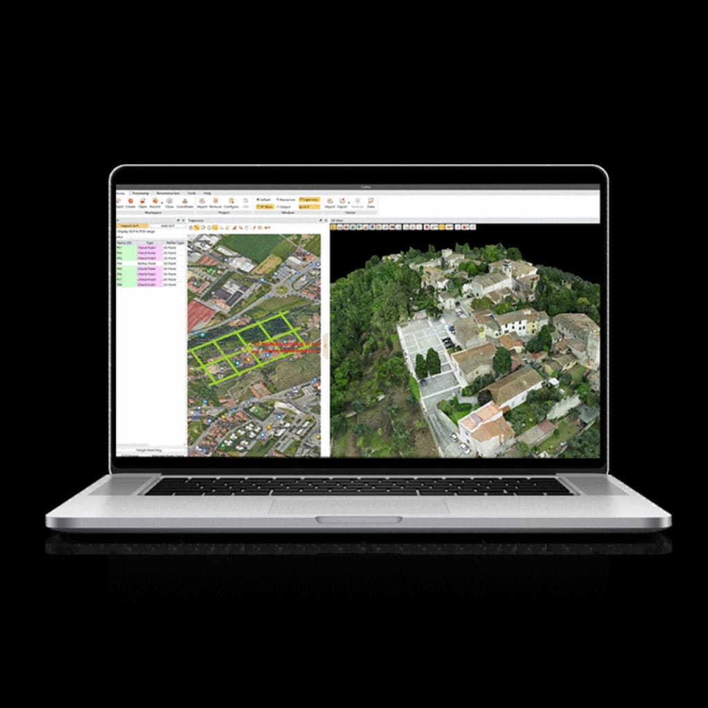
CoPre Quick and efficient processing of UAV & mobile mapping data
CoPre is a powerful and intuitive software ecosystem for quick and user-friendly processing of geospatial data gathered by UAVs and mobile mapping platforms. Supporting all CHCNAV LiDAR scanners, it provides immediate access to raw data and includes automated workflows for maximum efficiency. With proprietary data processing algorithms, it significantly improves the accuracy of post-processing results. The software provides a variety of useful features including accurate trajectory processing, point cloud and image georeferencing, point cloud colorization, filtering, and digital ortho model (DOM) generation. Advanced functions include multiple simultaneous dataset processing and layering, strip adjustment, and a reconstruction module that supports aerial triangulation. Operating system Microsoft Windows 7, 8, 10 (64-bit) Install package size Less than 2 GB File system NTFS Processor Intel® Core™ i7 (Minimum) Intel® Core™ i9 (Recommended) RAM 8 GB (Minimum) 32 GB or more 64 bit OS (Recommended) Hard disk 500 GB SSD Drive (Minimum) 1 TB SSD Drive (Recommended) Large project disk option RAID 5, 6, or 10 w/ SATA or SAS drives Graphics card Nvidia GeForce 2 GB (Minimum) Nvidia GeForce 6 GB+ (Recommended) Display 1024 × 768 (Minimum) 1920 × 1280 (Recommended) License type Permanent SW registration code Time limited SW registration code USB dongle driver (optional) SW upgrade Online version chech Manual install package Supported Language English Russian Chinese
.jpeg)
YellowScan CloudStation LiDAR point cloud processing software
CloudStation is the proprietary software developed by YellowScan to generate and visualize point-clouds. An all-integrated solution with a user-friendly interface, it provides the ability to extract, process and display data immediately after flight. Auto-generation of strips and the production of LAS files can be performed in just a few clicks, providing a faster workflow and enhanced productivity. Advanced visualization tools include 3D viewing, EDL filtering and vertical slicing. Key features User-friendly graphical interface Automatic or custom strip selection Process and export in .LAS / .LAZ format Advanced visualization tools Project setttings: Coordinate System, LiDAR profile, angle range... To allow for remote work in the field, customers have the option to test out the license for up to 30 days. The software is provided with support, maintenance and updates at no additional costs during the first year after purchase.
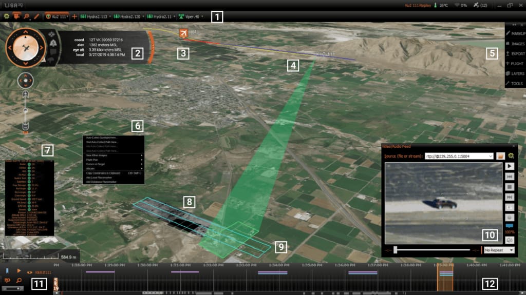
Lisa 3D – C2 & PED Software for actionable intelligence Fully integrated mission planning and multi-sensor data processing
Lisa 3D is a fully integrated software package that provides intuitive mission planning as well as real-time data analysis for multiple sensors, including radars, EO/IR payloads, vessel AIS and a variety of other sources, generating actionable intelligence for improved decision-making. ISR (intelligence, surveillance and reconnaissance) drone operators can create detailed data collection plans for multiple sensors and modes, and use these to generate flight plans. Lisa 3D provides real-time tracking of sensors and monitoring of flight characteristics, and mission plans and collection modes can be dynamically altered on the fly. Lisa 3D supports a wide range of file types for import and export, and data products from multiple sensors can be easily viewed, overlaid on a 3D map, annotated and marked.
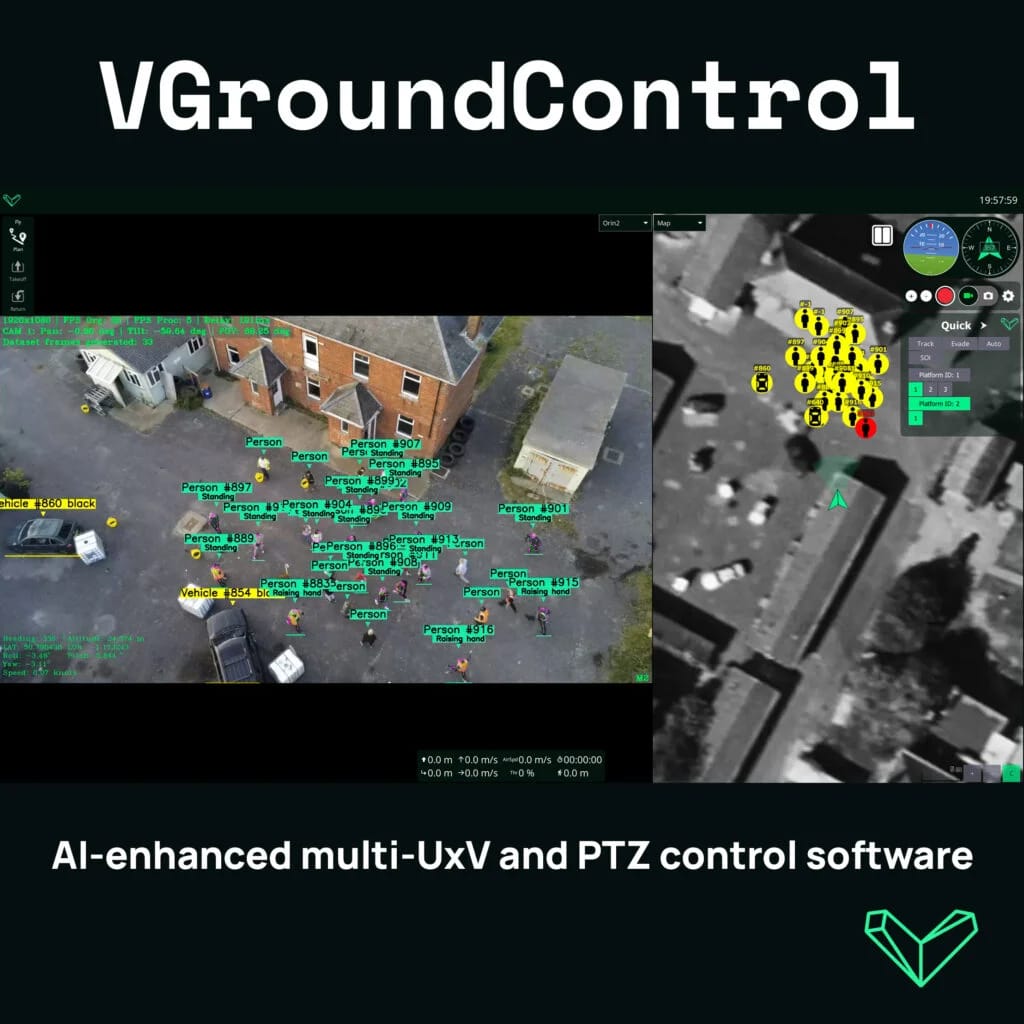
VGroundControl AI-enhanced multi-UxV and PTZ control software
Our enhanced version of the popular QGroundControl drone software, customised for Defence and Security applications. VGroundControl allows one operator to control and monitor multiple AI-powered UxVs or ground-based Pan/Tilt/Zoom cameras from mobile or desktop user interface.
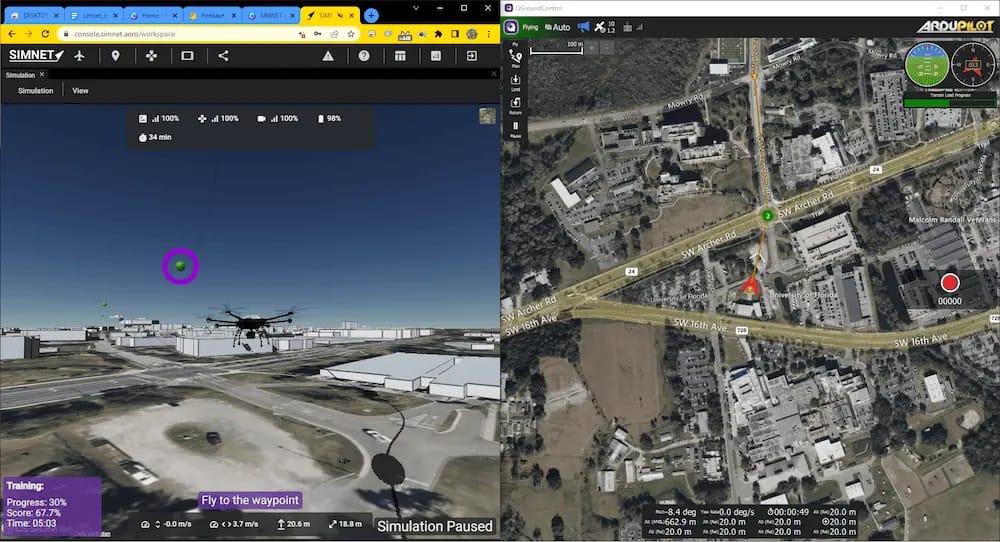
SIMNET Simulator Web-based UAS flight simulation and operator training
SIMNET Simulator is an advanced web-based UAS simulation and operator training platform that stands out for its comprehensive capabilities. It streamlines the simulation process by eliminating the need for software installation, updates, or compatibility concerns, allowing users to access the platform from any operating system via a web browser. With its global terrain model, users can simulate flights in any location worldwide, using satellite-based imagery and elevation data. The platform offers turnkey simulation of popular flight control systems like ArduPilot and PX4, enabling seamless connection with various Ground Control Station software for planning and executing autonomous missions or for manual control integration. Additionally, SIMNET Simulator enhances training realism through its Virtual Reality support, compatible with accessible devices like the Oculus Quest 2 headset. Designed for UAS service providers, independent operators, and training institutions, SIMNET Simulator is a versatile tool that helps in training pilots, maintaining pilot proficiency, and planning and rehearsing missions. It allows users to train in specific real-life locations and scenarios, ensuring pilots are well-prepared, proficient, and able to minimize risks and costs in actual flight scenarios.